Hurricane Kate (1985)
Though the system tracked erratically during the first hours of its existence, the intensification of a region of high pressure to the cyclone's north caused Kate to turn westward.
Kate made its first landfall on the northern coast of Cuba at this intensity prior to emerging as a slightly weaker storm during the evening hours of November 19.
Heavy rainfall in Cuba caused numerous mudslides and flooding, killing 10 people and leading to severe agriculture damage.
Hundreds of thousands of residents were evacuated, and Florida governor Bob Graham declared a state of emergency for six counties; this was later cancelled following the relatively minor impacts of Kate.
Before the formation of Hurricane Kate, a ridge was located across the southeastern United States for much of the autumn of 1985; concurrently, a major trough persisted across the western portion of the country.
As a result, weather conditions across the Gulf of Mexico and western Atlantic Ocean in November were more typical of a pattern in late September, including sea surface temperatures of 81 °F (27 °C).
It gradually organized due to the favorable conditions, and on November 15, a Hurricane Hunters flight into the area indicated the development of a tropical cyclone.
As gale-force winds were already present, the system was immediately declared Tropical Storm Kate, about 240 miles (385 km) northeast of San Juan, Puerto Rico.
[4][5] The hurricane maintained its well-defined eye while moving across northern Cuba, and about 12 hours after making landfall, it emerged into the southeastern Gulf of Mexico just east of Havana.
[7] The combination of cooler waters and wind shear from the front weakened Kate to an intensity of 100 mph (160 km/h) by the time the hurricane struck Crooked Island near Mexico Beach, Florida late on November 21.
[5] Until 2011, Kate's was considered the second-latest hurricane landfall in the United States, behind only a cyclone in 1925 that struck on December 1; however, a systematic reanalysis indicated that the 1925 system was only a tropical storm.
Officials recommended evacuation of the Florida Keys, leading to heavy traffic on the Overseas Highway and prompting the Red Cross to open 12 shelters.
[14] Shortly after the storm reached its peak intensity on November 20, the NHC issued a hurricane watch from Grand Isle, Louisiana, to Cedar Key, Florida.
[15] The USS Lexington left port from Naval Air Station Pensacola to ride out the storm in open waters, and aircraft in the region were flown inland.
[16] About 100,000 people along the Florida Panhandle were told to leave their houses after Governor Bob Graham issued evacuation orders in 13 counties.
[18] Portions of the Florida Gulf Coast had been threatened by Hurricane Elena earlier in the season, and some evacuees of that storm intended not to leave during Kate due to the poor shelter conditions that they had experienced.
[18] After Kate moved ashore, the NHC issued gale warnings along the East Coast of the United States from St. Augustine, Florida to Chincoteague, Virginia.
[11] In Jamaica, heavy precipitation caused mudslides, which in turn blocked 23 major and minor roads and destroyed many bridges, culverts, and drains.
[22] As Kate moved across northern Cuba, it produced strong winds that peaked at 75 mph (120 km/h) in Sagua La Grande.
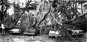
[26] While moving ashore, Kate produced an 11 feet (3.4 m) storm surge at Cape San Blas,[7] causing beach and dune erosion in Gulf County.
[29] Just two months after Elena ravaged the Apalachicola Bay shellfish harvesting industry, Hurricane Kate destroyed remaining oyster beds, leaving many oystermen in the area without jobs.
[27] About 90 percent of Florida's capital Tallahassee, or about 80,000 people, lost power, and along the coast from Panama City to Apalachicola, the storm left about 30,000 homes and businesses without electricity.
[35] Portions of southwestern Georgia experienced heavy damage from flash flooding and winds, and several secondary roads were washed out.
[7] In the month after Hurricane Kate struck the island, the government of Cuba issued a request to the United Nations (UN) World Food Council for international assistance.
In response, various UN member nations collectively provided $60,000 for pesticides; $250,000 for herbicides, fungicides, and potato seeds; and $1.381 million in cooking oils and beans to fulfill the dietary needs of over 475,000 people for 60 days.
[39] On December 3, 1985, President of the United States Ronald Reagan declared seven Florida counties as disaster areas, making them eligible to receive federal aid.
[40] Due to the widespread power outages along the Florida Panhandle, electrical companies enlisted extra workers to repair downed lines.
[41] Some sections of coastline already suffering from severe erosion lost additional swaths of beach to a 10-foot (3 m) storm surge and strong waves.

Tropical storm (39–73 mph, 63–118 km/h)
Category 1 (74–95 mph, 119–153 km/h)
Category 2 (96–110 mph, 154–177 km/h)
Category 3 (111–129 mph, 178–208 km/h)
Category 4 (130–156 mph, 209–251 km/h)
Category 5 (≥157 mph, ≥252 km/h)
Unknown